Contents tagged with JPEG
-
GPS Coordinates in JPEG C# Example - Looks like there is a western side to the world as well

-
Embedding GPS coordinates and other info in JPEG images with C#
GPS and images are a dynamic duo. GPS modules are becoming cheaper and cheaper which means that we would see more gadgets embedded with a GPS as a standard. Cameras and phones are probably the ones that would be on the front line of GPS embedding early adoption. Currently there is the Nokia's N95 cell phone and there might be soon to see camera's with embedded GPS modules (??) and some funny looking , cumbersome integrations .
So having these two modules is a blessing for geotaggers.
What is geotagging you ask?
Taken from wikipedia
Geotagging, is the process of adding geographical identification metadata to various media such as websites, RSS feeds, or images and is a form of geospatial metadata. This data usually consists of latitude and longitude coordinates, though it can also include altitude, bearing, and place names.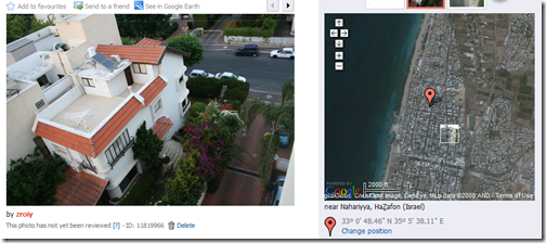
And if you're lucky enough to have a GPS that can track export it's data , you can embed the GPS coordinated into the JPEG images. Which means that on top of storing things like the camera model and time of picture taken , it can also store the specific location where the picture was taken. And to take it even further , there are image loading web services that locate on a map pictures that were embedded with their respective GPS coordinates . Panoramio.com is my favorite, Flickr used to support this by simply putting the latitude and longitude as tags , but it looks like it is no longer supported. Use Panoramio , it does the job.