Power Outage Maps from Around the World
Whew. It's been a long time since I blogged but I think it's fine time to get back into it and this seemed to be a useful start.
My job for the last few years has been in the electrical industry, specifically dealing with electrical distribution for Alberta in Canada. A few years back I came across a list published by Edward Vielmetti that listed power outage maps for all 50 states and other countries. Since I built it, I contributed my own map for FortisAlberta to the list. The original list has since gone by the wayside so I rescued it from the Wayback Machine and will continue to maintain it here. Feel free to email me with updates, questions, ideas, small marsupials, credit card numbers, etc. As I find time I will update the images and information as best I can.
IMPORTANT!! The last version I could get of this content from the Internet was from May of 2016 and the last update to that version of the list was from May of 2015. So this information is terribly out of date. Phone numbers, links, and information here has not been updated yet. Please do not use this for emergency reference. Always refer to your local authorities and resources for the latest information during a power outage.
The list is known to be incomplete, but the list from Wikipedia (outage management system) is also incomplete. To be overly comprehensive, if there are screen captures that I can gather, I will; they will not be current when you look at them, but I will time and date stamp them as best I can.
Wherever possible, I'm also capturing service area or service territory maps, mobile device apps, high capacity transmission interconnection maps, media contact information, regulatory agencies, and regional coordinating bodies.
Updates
May 7, 2015. Updates to Texas, including Coserv (Denton County TX).
November 2, 2014. Updates to Maine, due to winter storms there; added Maine Public Utilities Commission map. Added load shedding page for Eskom (South Africa) and PGCB (Bangladesh) after large scale power outage in both countires. Added NB Power (New Brunswick, Canada), no maps.
August 1, 2014. Updated Fortis Alberta.
March 13-14, 2014. Updated Maine, Maryland, Virginia.
February 11, 2014. Added Sawnee EMC in Georgia north of Atlanta.
December 21, 2013. Reviewing Texas. Added load graph from ERCOT, map for San Bernard Electric Cooperative, map for AEP Texas, entry for Sam Houston Electric Cooperative, map for Austin Electric.
October 4, 2013. Added South Dakota Rural Electric Association map during early season winter storm Atlas. Update Progress Energy Florida to reflect merger with Duke Energy. Added map for Gulf Power (Florida), Mississippi Power. Still no map for Alabama Power. Preparations for TS Karen in the Gulf. Updates to Arizona, Saskatchewan, PEI.
July 10, 2013. Updated Twitter account for Arizona Public Service, added central Arizona's Salt River Project; also updates for the Toronto, Ontario, Canada area.
June 13, 2013. Added new maps from the Southern Company for Georgia Power. No map available for Alabama Power and Gulf Power, also Southern Company utilities.
October 26-29, 2012. Updates for Hurricane Sandy. Con Edison (NYC) has a new link to their storm center. Updated PEPCO media relations contact. Add Delmarva Power mobile apps. Update PSEG twitter. Add NSTAR (Massachusetts).
August 28, 2012 updates several Louisiana electric cooperatives in advance of Hurricane Isaac, as well as details for Mississippi Power. Quick link: Entergy Storm Center (New Orleans + much of Louisiana). News coverage: WWL-TV.
July 10, 2012 updates Alberta after AESO initiates rolling blackouts on EPCOR in response to extreme heat and power plants going offline.
June 25, 2012 has additional Florida updates for Tropical Storm Debby.
May 27, 2012 has updates from Florida for Tropical Storm Beryl, including new information in Jacksonville, Florida (JEA), Tampa Florida (TECO / Tampa Electric), and updated for Clay Electric (Gainesville).
May 14-16, 2012 notes visits from SurvivalBlog (thanks for the link) and an update of Progress Energy's map for North and South Carolina; maps also added for Vermont (CVPS), eastern Washington (Avista), metro Atlanta (GreyStone), Colorado Springs Utilities, Duke Energy (Indiana) and an entry for Wyoming (Rocky Mountain Power).
April 30, 2012 adds a Twitter feed for Oklahoma Gas and Electric (@OGandE). Some of the OG&E maps render at weird sizes in the Chrome browser I'm using.
April 15, 2012 adds Kansas City Power and Light's map, powered by Obvient Strategies (now a division of Ventyx).
January 12, 2012 adds the service alert map from Puget Sound Energy, which serves Washington State. This map is only activated in severe weather; PSE reported 220,000 homes without service due to heavy snowfall.
November 30 - December 1, 2011 looks at the Santa Ana winds that are affecting California (LA Times), causing power outages and a risk of fires. An LADWP storm outage map at 6:00 p.m. December 1, 2011 shows widespread outages affecting about 118,000 of that utility's 1.4 million customers. Outages in Utah (no maps) and New Mexico are also blamed on high winds.
November 15, 2011 looks at Ohio and Texas.
November 11-12, 2011 adds media contacts and maps for Duke Energy in North Carolina. I'm also working to incorporate a set of international outage information for telco and internet services, which doesn't neatly fit the state-by-state organization of the power grid. If you are in western Massachusetts, a WMECO ratepayer has built their own outage page suitable for even very dumb mobile phones.
A November 9, 2011 update starts to collect media contact pages, especially for utility companies that do not currently publish maps, and I'm looking at Alaska, Michigan, Washington, and Wisconsin.
A November 7, 2011 update adds PSE&G in New Jersey and RG&E in Rochester, NY, and updates several maps in Oklahoma.
The October 30, 2011 "Snowtober" update includes hits to the power grid from the snowstorm .
The September 9, 2011 updates focus on southern California and Arizona, where a widespread power outage occured when the North Gila – Hassayampa 500 kV transmission line near Yuma, Ariz went off line; maps added include the SDGE outage map, a 2003 map of high capacity California interconnects, and a map of utility service areas in California.
The September 6, 2011 updates include new KML (GeoRSS) thematic maps for ConEdison (NY), Pepco (DC), Progress Energy (NC/SC), Delmarva (DE/MD) and Atlantic City Electric (NJ), via Google Crisis Response, plus a new map for Allegheny Power.
The August 25 and 29, 2011 updates includes nine new maps along the US east coast, covering power outages due to Hurricane Irene.
Warning
Don't touch a downed wire. If you don't know who to call to report an emergency associated with a power outage, call 911. Avoid dire mofo.
United States. Eaton Blackout Tracker. Aggregated information about power outages, their causes, and the relative impact of each one; not real time.
United States (Midwest): Midwest ISO. Regional coordination of wholesale power transfers in Michigan, Indiana, Illinois, Missouri, Iowa, Minnesota and Manitoba. Midwest ISO Real Time Locational Marginal Price Contour Map.
United States (14 western states). Western Electricity Coordinating Council. The Principal Transmission Map and the Planned Facilities Map are available to WECC members only or on receipt of approval from WECC’s Manager of Planning Services.
United States (Northwest). Northwest Council: Power Generation in the Northwest map shows top power producers in each category, or those producing more than 25mw.
Alabama: Alabama Power storm center (no maps). Alabama Power makes maps for internal use; here's how they do it, in a 2009 ESRI user group presentation. A Southern Company. Twitter: @alabamapower. Facebook: AlabamaPower.
Alabama (Dothan): Wiregrass Electric Cooperative Outage Map. Map requires Silverlight plugin. The WEC Android app also has outage information for mobile devices.
Alabama. CAEC Outage Viewer. Call 1-800-619-5460 to report an outage or dangerous condition.
Alaska (statewide): Alaska Power Association. Statewide electric utility trade association. Member and public relations: 907-771-5711.
Alaska (Juneau): Alaska Electric Light and Power outage log. Detailed reporting of each outage incident, with the cause, location and duration noted. Juneau is not connected to a larger power grid. No map. Please call 1-888-434-9844 if you experience an outage
Alaska (Anchorage): Municipal Light and Power (no maps). To report an outage, call 907-279-7671
Arizona (Phoenix). Arizona Public Service (APS) Outage Center (no maps). Twitter: @apsFYI. Facebook: apsfyi. Call 855-OUTAGES to report an outage.
c
Arizona (Central Arizona). Salt River Project Public Outage Map. (requires Silverlight) Twitter: @srpconnect.
Arizona (Tucson). Tucson Electric Power (no outage center, no maps). Twitter: @TEPOutageInfo. Updated October 5, 2013.
Arizona (Southern - Pima, Santa Cruz counties, excluding Tucson): TRICO Electric Coop. No maps.
Arizona (Southern, Western - Santa Cruz, Mohave County): Unisource Energy (No maps). Twitter: @UESPowerOutages. Updated October 5, 2013.
Arkansas (Little Rock). Entergy Storm Center. In addition to showing customer level problems, Entergy Arkansas also shows lines that are de-energized in its distribution system. Mobile access via the Entergy App (iPhone).
Arkansas (Fayetteville, Texarkana). SWEPCO Outages and Problems. Twitter: @swepconews. Facebook: Southwestern Electric Power Company - SWEPCO. Please report safety hazards by calling 1-888-218-3919.
Arkansas (Northwest): Empire District Electric Company Power Outage Map. See the Missouri entry for Empire for a map; only a few customers are served in Arkansas.
California (entire state). California Independent System Operator (no maps). Power grid coordination among utilities at the wholesale level. Graph of aggregate California actual and forecast electric supply and demand.
California (statewide). California Energy Commission Energy Maps of California. Detailed statewide maps, including this map of California electric utility service areas.
California. Consortium of Electric Reliability Technology Solutions. Research into grid reliability and stability, hosted at Lawrence Berkeley Laboratories. 2003 California power grid study includes this map.
California (far north). Pacific Power Outage Information For California (no maps). To report an outage or if you do not see your outage listed and would like an update, call us anytime toll free at 1-877-508-5088. To improve service to you, we are working to enhance our online outage information to include interactive maps in the future. (as of December 2011)
California (San Francisco). PG&E Outage Map. Twitter: @PGE4Me . If you need to report an outage, please call 1-800-743-5002.
California (Los Angeles). Los Angeles Department of Water and Power. For real-time outage information, please call us anytime at 1-800-DIAL DWP. Twitter: @LADWP . News updates: LADWPNews.com. No interactive map tracker for the general public. The map below was produced in response to the December 1, 2011 Santa Ana winds and shows over 114,000 customers without power in LA.
California. Southern California Edison Outage Center, Outage Maps (new), Outage List View (suitable for mobile use). Twitter: @SCE. Facebook: SCE. If your electricity stays off for longer than a few minutes, call 800-611-1911. [Updated 3/12/14.]
California (San Diego) SDGE Outage Map. Twitter: @SDGE . Call 800-411-7343. Area code 619.
Colorado (Denver). Xcel Energy Outage Map. To report an outage, call 1-800-895-1999. Twitter: @XcelEnergyCO.
Colorado (Colorado Springs). Colorado Springs Utilities Electric Outage Map.
bhe
Connecticut. Connecticut Light and Power Outage Map. Table of Connecticut Light and Power Outages (text, formatted for mobile phone). Twitter: @CTLightandPower. Call 800-286-2000. [Confirmed 10/27/12]
Connecticut (New Haven). United Illuminating Outage Map. Call 800.722.5584. Twitter: @unitedillum [Confirmed 10/27/12]
Delaware. Delmarva Power Outage Map. Delmarva Thematic Areas Map (KML). Twitter: DelmarvaConnect. The Delmarva Power mobile apps include support for iOS, Android, and Blackberry. [Updated 10/27/12]
Florida (Southern, Miami, Tampa). Florida Power and Light FPL Power Tracker. Twitter: @insidefpl. Report an outage: 1-800-468-8243.
Florida. Progress Energy Florida Outage Map. Twitter: @progressenergy, @ProgEnergyFL. Facebook: Progress Energy Florida. Call (800) 228-8485 with outage reports, or use the Progress Energy outage reporting tool to report online. Map below shows damage due to Tropical Storm Debby; it is updated 4 times a day. Progress Energy merged with Duke Energy in 2012; though the Twitter account is still listed on the Duke Energy site, it appears to be down. Twitter: @dukeenergy , @dukeenergystorm .
Florida (Orlando). Orlando Utilities Commission Outage Map. If you need to report an outage, call the Emergency Service Hotline at 407.823.9150 (24 hours) in Orlando/Orange County and 407.892.2210 (24 hours) in St. Cloud/Osceola County.
Florida (Northern, Gainesville). Clay Electric Cooperative Outage Map. A Touchstone Energy Cooperative. Outage map shows diamond-shaped outage grid, plus a per-county report showing the percentage of customers out in each area. Call 1-888-434-9844 to report an outage.
Florida (Jacksonville). JEA Outage Info. To report a problem, call (800) 683-5542. Twitter: @NewsfromJEA. News media coverage includes WOKV News/Talk 690 AM (Facebook)., WOKV.COM, newspaper Florida Times-Union at Jacksonville.com.
Florida (Tampa). Tampa Electric Outage Map. Tampa Electric is part of TECO. Call 877-588-1010.
Florida (Pensacola to Panama City). Gulf Power, a Southern Company. Facebook: Gulf Power Company; used in times of emergency to distribute updates from their Distribution Control Center. New map: Gulf Power Outage Center. Updated October 4, 2013.
Florida (Panhandle). Talquin Electric Cooperative Outage Status Map. Facebook: Talquin Electric Cooperative. "Powered by DataVoice". Updated October 4, 2013.
Florida (Gainesville). Gainesville Regional Utilities (GRU). No maps. Twitter: @GRUStormCentral. Call 352-334-3434.
Georgia (Atlanta, statewide). Georgia Power Outage Center . Twitter: @georgiapower. Call 888-891-0938 to report an outage. Southern Company service area map. Georgia Power uses NaviGate from Gatekeeper Systems for visualization of their distribution network (case study). New: Georgia Power Outage Map. Map credit: iFactor.
Georgia (NE of Atlanta, Athens). Jackson EMC Outage Map. Map hosted by Sienatech.
Georgia (NW of Atlanta, Cobb County). GreyStone Power Outage Status Map. Map powered by dataVoice. Unusually, this map reports outages by substation as well as by city and county.
Georgia (NE of Atlanta). Sawnee EMC Current Outages. The Twitter account @SawneeAssist is protected. A mobile outage map is set up for smart phones and tablets. Service area map.
Hawaii. Hawaiian Electric Company (HECO). No maps.
Idaho. Idaho Power Service Area Map (no outage information). Follow @idahopower on Twitter or the Idaho Power Facebook page for information during severe power outage incidents.
Illinois. Ameren llinois Outage Center; Ameren Service Territory Map (includes Missouri)
Illinois (Chicago area, northeast): ComEd Outage Map. Call 1-800-Edison-1 to report a downed power line. For News Media Inquiries, contact ComEd Media Relations at +1 312 394 3500. ComEd is an Exelon company. Exelon Corporation: Contact Us.
Indiana. Duke Energy Current Outage Map. If the power goes out, call 1-800-343-3525. [Updated 10/27/12]

Indiana (northwest). Indiana Michigan Power Outages and Problems map.
Indiana (north) NIPSCO Current Power Outages.
Indiana (Indianapolis). Indianapolis Power and Light Company OutageMap. If you are currently experiencing an outage, please call 317-261-8111.
Iowa. Iowa Association of Electric Cooperatives Outages.
Iowa. MidAmerican Energy MEC Outage Watch.
Kansas (Kansas City). Kansas City Power and Light Powerwatch. Powered by Obvient Strategies.
Kansas (Topeka, Wichita). Westar Energy Outage Map.
Kentucky (Louisville, statewide). LG&E / KU / ODP Outage Map
Kentucky (eastern). Kentucky Power Outages and Problems.
Kentucky (Lexington). Blue Grass Energy Outage Viewer. To report a power outage please call 1-888-655-4243.
Louisiana. CLECO Current Power Outage Information. Map shows overlay of weather radar, with Hurricane Isaac of 2012 displayed.
Louisiana. (Lafayette) SLEMCO Current Outages.
Louisiana (New Orleans). Entergy Storm Center. This screen shows outages reported just after Hurricane Isaac made landfall in 2012. Mobile access via the Entergy App (iPhone).
Louisiana (Slidell). Washington - St Tammany Electric Cooperative Storm Center. Detail view shown; note that the outage reporting lets you gather detail down to the substation and feeder level. A Touchstone Energy partner.
Louisiana (Shreveport): SWEPCO Outages and Problems.
Maine. Transmission and distribution map for utilities statewide, from the Maine Public Utilities Commission. [Updated 11/2/14]
Maine (Augusta): Central Maine Power outage reporting (no maps). CMP Service area map (PDF). To report an outage, call 1-800-696-1000. Twitter: @CMPCo [Updated 11/2/14]
Maine. Bangor Hydro and Maine Public Service merged in January 2014 to form Emera Maine. The Emera Maine outage map also includes detail on every single outage in the service territory, and a total count of outages system wide. Contact 1-855-EMERA-11 for more info. Twitter: @EmeraME. [Updated 11/2/14].
Maine (Bangor): Bangor Hydro outage map. Merged with Maine Public Service to form Emera Maine. [Updated 3/12/14]. Old service territory map.
Maryland. Electric utility service area map, as of 2008; from PPRP.
Maryland (Baltimore area, BWI): Baltimore Gas and Electric power outage map. Power Out or Downed Wire? Call 877-778-2222. Media only: 888.232.1919 . An Exelon Company. [Updated 3/12/14]
Maryland (Delmarva), Delmarva Power Outage Map. (See listing under Delaware). Download a mobile app from Delmarva Power. [Updated 3/12/14].
Maryland: Allegheny Power, A FirstEnergy Corporation. Allegheny Power Outages Map.
Maryland (Delmarva): Choptank Electric Cooperative Outages. Choptank serves 9 counties on Maryland's Eastern Shore: Caroline, Cecil, Dorchester, Kent, Queen Anne's, Somerset, Talbot, Wicomico, Worcester. [Updated 3/12/14].
Maryland (DC suburbs): Pepco StormCenter. KML: Pepco Thematic Areas Map. Stay away from downed wires, call 1-877-737-2662 to report an outage. Media relations (reporters only): 202/872-2680 Twitter: @PepcoConnect 8a-5p M-F. [Updated 3/12/14].
Maryland (Southern): Southern Maryland Electric Cooperative. SMECO Outage Map. Report an outage: 1-877-747-6326. [Updated 3/12/14].
Massachusetts. (Mass. Electric): National Grid Outage Map.
Massachusetts (WMECO, Springfield, Amherst) Western Massachusetts Electric Outage Map. WMECO delivers power to more than 200,000 customers in 59 towns in western MA. Twitter @WMECO monitored during business hours. A Northeast Utilities company. A subscriber has built their own WMECO service outage page suitable for mobile phones.
Massachusetts (Cape Cod, Boston): NSTAR Outage Map. For mobile devices or low bandwidth: NSTAR Outages. Call to report a power outage. 1-800-592-2000. Twitter: @NSTAR_News. [Added 10/29/12]
Michigan (statewide). Michigan Public Service Commission. Statewide energy regulator. Michigan Electric Utility Service Area Map.
Michigan (Central Upper Peninsula, Ishpeming, Negaunee, Escanaba, Houghton, Hancock): Upper Peninsula Power Compan Current Electric Outages.
Michigan (City of Detroit municipal system). Detroit Department of Public Lighting (no maps). Contact (313) 267-7202.
Michigan (Detroit metro area, DTW). DTE Energy Outage Map (interactive), DTE Zip Code Outage Map (PDF). iPhone users can download the DTE iPhone outage tracker app for free. Twitter: @DTE_Energy . Call 800-477-4747. Media relations: 313-235-5555.
Michigan (central, western, northern Lower Peninsula) Consumers Energy: Report an Electric Outage (no outage maps). Electric and Gas Service Territories. If you are news media: Consumers Energy Media Contacts. Twitter: @consumersenergy .

Michigan (southwest). Indiana Michigan Power Outage Map.
Minnesota (statewide). Minnesota Geospatial Information Office Public Utilities Infrastructure Information for Minnesota. Electric, natural gas, water and sewer maps. Detailed statewide electric utility service area boundaries are not currently available. A detailed Minnesota electric transmission lines and substations map from 2007 shows service of 60 kV or larger; this map is an excerpt.
Minnesota (Duluth). Minnesota Power Outage Map.
Minnesota (Northeast). Lake Country Power Outage Viewer.
Mississippi (Western). Entergy Mississippi Storm Center. Mobile access via the Entergy App (iPhone). Facebook: Entergy Mississippi. Twitter: @entergyms . For storm alerts, text REG to 368374. To report a power outage, call 1-800-9OUTAGE. Entergy also serves adjacent Louisiana, Arkansas, and Texas customers with outage reporting on the same map.
Mississippi. Mississippi Power. Facebook: Mississippi Power. If you lose power, call 1-800-ITS-DARK (1-800-487-3275). Map: Mississippi Power Outage Map. Updated October 4, 2013.
Mississippi. Coast Electric Power Association (no maps). Report an outage: 877-7MY-CEPA. Facebook: Coast Electric. Serves 77,000 customers in southern Mississippi.
Missouri (Kansas City, Independence). Kansas City Power and Light Powerwatch. "Powered by Obvient Strategies".
Missouri (St Louis area): Ameren Power Outage Map; Ameren Service Territory Map.

Missouri (west of St Louis): Cuivre River Electric Outage Viewer. Please call 1-800-392-3709 to report an outage. Smart phone link.
Missouri (Southwest, Joplin area): Empire District Outage Map.
Montana. Northwestern Energy. (No maps.) In June 2011, a fawn dropped by an eagle cut power to a neighborhood in East Missoula, affecting about 30 homes (Reuters story).
Nebraska. Nebraska Public Power District Storm Center Outage Map. Twitter: @NPPDstormcenter. If you have an outage and get your electric bill from NPPD, call us at (toll free): 1-877-ASK-NPPD (275-6773).
Nebraska. Omaha Public Power District Power Outage Map. Outages are reported on a grid, either as absolute numbers or as % of total subscribers (shown).
Nevada. NV Energy (no maps).
New Hampshire. New Hampshire Electric Co-op Outage Map. About 78,500 customers served.
New Hampshire. Public Service of New Hampshire Outage Map. Mobile site: PSNH Outage List. Call to report a power outage. 1-800-662-7764. Twitter: @PSNH
New Hampshire (Capitol, Seacoast regions). Unitil Energy Outage Information (no maps). Twitter: @Unitil.
New Jersey (northern). Orange and Rockland Storm Center.
New Jersey (Jersey Central Power and Light). FirstEnergy Current System Outage Map. Phone 1-888-544-4877.
New Jersey (Bergen, Essex, Hudson, Mercer, Middlesex, Passaic, Somerset and Union counties): PSE&G Outage Center. PSE&G, NJ's largest utility, services 2.1 million electric customers and 1.7 million gas customers. Call 800-436-PSEG. Twitter: @PSEGdelivers. [Updated 10/29/12]
New Jersey (Atlantic City, southern). Atlantic City Electric Outage Map. KML: Atlantic City Electric Thematic Areas Map. If you see a downed line, call 800-833-7476. Twitter: @ACElecConnect
New Mexico. El Paso Electric Trouble and Outages (no maps)
New Mexico (Albuquerque). PNM Power Outage Map. Call 1-888-DIAL-PNM (888-342-5766) to report your outage. This map is from the windstorms of December 1, 2011.
New York (statewide). New York Independent System Operator. Wholesale power coodination across New York State.
New York /New Jersey (New York City area). NYCPowerStatus.com has consolidated information from Con Edison, LIPA, and PSEG, with graphs that chart system outage and restoration.
New York (New York City). Con Edison Storm Center. KML: ConEdison Power Outages Thematic Areas Map.
New York (Long Island). Long Island Power Authority Storm Center Outage Map.
New York (Poughkeepsie, Kingston) Central Hudson Storm Center, powered by iFactor.
New York (Buffalo, upstate). National Grid Outage Map.
New York (Upstate). NYSEG Outage Central. No maps, but detailed city by city and outage by outage information in table format. Call 1.800.572.1131. Twitter: @NYSEandG.
New York (Rochester). RG&E Outage Central. No maps. Outages are reported by city and by street.
New York (Rochester). RGE Outages plots the approximate locations of power outages in Rochester, New York, and is updated every ten minutes. The source data for this map is published by RG&E, but all map-related blame should go to Ryan Tucker. You can find the source code on GitHub.
North Carolina. (Charlotte, Greensboro). Duke Energy Current Outages. Call 1-800-POWERON to report outages and get an estimated time of restoration. Los clientes hispanos pueden llamar 1-866-4-APAGON. Media contact line: 800-559-3853 or 704-382-8333 for news media only.
North Carolina (Raleigh/Durham, Asheville). Progress Energy Outage Map. An option on the map shows an outage history with restoration progress, as well as a breakdown of outages by county. KML: Progress Energy Thematic Areas Map. Powered by iFactor. Progress Energy also serves a part of eastern South Carolina.
North Dakota (Fargo). Xcel Energy Outage Map.
Ohio (statewide). Electric industry maps of Ohio, provided by the Public Utilities Commission of Ohio.
Ohio (City of Cleveland): Cleveland Public Power Outage Information (no maps). In the event of an outage, call 216-664-3156. Dial 811 before digging. CPP serves much of the city of Cleveland.
Ohio: (northern, Toledo, Cleveland suburbs, Youngstown): FirstEnergy Current System Outage Map. Consolidated map for Toledo Edison, Ohio Edison, and Illuminating Company. Media contacts for news media only.
Ohio: (southeast, Columbus, Findlay, Athens, Canton, Chillicothe): AEP Ohio Outages.
Ohio (south central) South Central Power Company Outage Map.
Ohio: (Cincinnati): Duke Energy Power Outage Map

Ohio (Dayton): Dayton Power and Light Outage Map.
Oklahoma (southwestern): Cotton Electric Cooperative Outage Map.
Oklahoma (Tulsa, Lawton, McAlester): PSO Outages and Problems map. Public Service Company of Oklahoma, a unit of AEP, serves over 530,000 customers in 45 Oklahoma counties. Twitter: @publicserviceco
Oklahoma (OKC): OG&E System Watch map. Includes graphs of outages by hour of day and recent historical outage counts, plus a weather overlay. Updated every 15 minutes on the quarter hour. Twitter: @OGandE
Oregon (Portland, Beaverton, Salem). Portland General Electric Outage Map.
Pennsylvania (statewide). Pennsylvania Public Utility Commission. Regulation and reporting on statewide energy utilities, with jurisdiction over 11 electric utility companies that serve most of the commonwealth.
Pennsylvania. Citizens Electric of Lewisburg outage map.
Pennsylvania (Pittsburgh). Duquene Light Company Storm Center. (no maps) During storms, the Twitter account @DuquesneLight is updated. Area codes: 412, 878.
Pennsylvania (Philadelphia). PECO outage map. Call 800-841-4141 to report an outage. PECO is an Exelon company. Area codes: 215, 267.
Pennsylvania (Penn Power, Penelec, Met-Ed): FirstEnergy Current System Outage Map - Pennsylvania
Pennsylvania (suburban Pittsburgh, State College). Allegheny Energy Outage Status. Call 1-800-255-3443 to report an outage.
Pennsylvania (PPL; eastern) . PPL Outage Map. PPL service territory map. [Updated 11/2/12]
Pennsylvania: Northwestern REC Outage Web Map.
Rhode Island. National Grid outage map. Table of Rhode Island power outages (text, data from National Grid, hosted by WPRI).
South Carolina. Duke Energy Outage Map. Duke Energy Service Area Map.

South Carolina (Columbia, coastal). SCE&G Outage Map. Call 800-251-7234. Twitter: @scegnews
South Carolina (eastern, coastal). Progress Energy outage map. An option on the map shows an outage history with restoration progress, as well as a breakdown of outages by county. KML: Progress Energy Thematic Areas Map. Powered by iFactor. Progress Energy also serves a part of North Carolina. Progress Energy has been acquired by Duke Energy.
South Dakota. Xcel Energy. Call 1-800-895-1999. Xcel Energy Outage Map.
South Dakota. NorthWestern Energy (no maps). Call (800) 245-6977.
South Dakota (Rapid City). Black Hills Power Current Outages. Call 1-800-839-8197 to report an outage.
South Dakota. South Dakota Rural Electric Association Outages. Consolidated mapping, includes Black Hills Electric Coop, Butte Electric Coop, Grand Electric Coop, West River Electric Association, and 20+ other cooperatives.
Tennessee (statewide). Tennessee Valley Authority (no outage maps). Regional map shows TVA distribution map (PDF) to local power companies.
Tennessee (Memphis). MLGW Electric Outage Summary Map. First map I've seen that does outage accounting on a grid rather than by political boundaries, zip codes or internal subdivisions. Twitter: @MLGW.
Tennessee (Nashville). Nashville Electric Service (NES) Outage Map. Mobile version: Estimated customers without power. Facebook: Nashville Electric Service. Customer service: (615) 736-6900.
Tennessee (southern suburbs of Nashville): Middle Tennessee Electric Membership Corporation Outages. Report an outage through MTEMC's automated outage reporting line at 1-877-777-9111.
Texas: ERCOT grid reliability; aggregate demand, pricing. No maps.
Texas: San Bernard Electric Coop (Columbus, Hempstead, Sealy; west of Houston) http://66.63.235.29/Outages/
Texas: Sam Houston Electric Cooperative Storm Central. Call 1-888-444-1207 to report an outage.
Texas: CPS Energy Outage Center (San Antonio)
Texas: AEPTexas.com https://www.aeptexas.com/outages/ Outages by zipcode at the county level.
Texas (Austin): Austin Energy Storm Center.
Texas (southeast of Austin, including Bastrop): Bluebonnet Electric Outage Viewer. The map depicted shows damage to the system from the Bastrop County Complex Fire and was added on September 9, 2011.
Texas (El Paso): El Paso Electric Trouble and Outage (no maps). Call (915) 877-3400 to report an outage. News coverage from the El Paso Times.
Texas (Dallas/Fort Worth, Waco, Odessa, Midland): ONCOR Storm Center. Powered by iFactor, this map includes a weather overlay and detailed zip code and county level outage counts. Review at EPC Updates.
Texas (Houston): CenterPoint Energy Outage Tracker.
Texas: Texas New Mexico Power Service Areas. (no outage map)
Texas (Denton County): CoServ. Map includes weather overlay, powered by iFactor. Twitter: @CoServ_Energy (Updated May 7, 2015.)
Utah. Division of Public Utilities. Map of consumer owned electric utilities.
Utah. Rocky Mountain Power Outages (no map). To report an outage or if you do not see your outage listed and would like an update, call us anytime toll free at 1-877-508-5088. "To improve service to you, we are working to enhance our online outage information to include interactive maps in the future." (December 2011)
Vermont. Vermont Outages. Consolidated information from 20 utilities. The map depicts damage after Hurricane Irene caused widespread flooding.
Vermont. Central Vermont Public Service Outage Map. The map depicts outages as well as the CVPS service territory.
Virginia (State Corporation Commission). Virginia Electric Utility Electric Service Territories map (PDF).
Virginia (Norfolk, Richmond, Fairfax). Dominion Electric Outage Map. Call 1-866-366-4357. A Dominion Electric power outage summary breaks down outages by service region. Twitter: @DomVAPower. Facebook: Dominion Virginia Power. The map depicts damage after widespread flooding and high winds from Hurricane Irene. News coverage: NBC12 (WWBT), Richmond Times-Dispatch. [Confirmed 3/12/14]
Virginia (Lynchburg, Roanoke): Appalachian Power Outages and Problems.
Virginia (Blue Ridge, Bowling Green, Culpeper). Rappahannock Electric Cooperative Outage Map. A Touchstone Energy Cooperative; technology by Lockheed Martin.
Virginia (Manassas, Loudon, Fairfax, Prince William). NOVEC Outage Map. Facebook: NOVEC. Twitter: @NOVEC. [Updated 3/12/14]
Washington. The Washington Utilities and Transportation Commission regulates energy companies in the state. The Access Washington government portal has a comprehensive page of where to report a power outage to your Washington utility company, with over 35 company contact numbers listed.
Washington (Spokane, eastern Washington). Avista Power Outages. Avista serves over 350,000 customers. Call 1-800-227-9187 to report an outage; 24-Hour Media Line: 509-495-4174 for press inquiries only. Maps depict both outages and recent power restorations.
Washington (Seattle): Seattle City Light System Status. Seattle City Light provides power to nearly 1 million Seattle area residents. News release: New Outage Management System Enhances City Light Storm Response, November 2010. Outage Hotline (206) 684-7400
Washington. Puget Sound Energy. Call us for assistance any time of day at 1-888-225-5773. Puget Sound Energy serves more than 1.2 million electric & gas customers in Washington State, in Island, Jefferson, Kitsap, King, Pierce, Skagit, Thurston, Whatcom and Kittitas counties. A service alert map is activated only when there are major outages. Twitter: @PSEtalk. Facebook: pugetsoundenergy. The map shown depicts the January 2012 snowstorm.
Washington DC: Pepco StormCenter. KML: Pepco Thematic Areas Map. Stay away from downed wires, call 1-877-737-2662 to report an outage. Media relations (reporters only): 202/872-2680 Twitter: @PepcoConnect
West Virginia (northern). Allegheny Energy Outage Status. Call 1-800-255-3443 to report an outage.
West Virginia (Charleston): Appalachian Power Outage Map.
Wisconsin (Northeast: Green Bay, Waupaca, Stevens Point, Wausau, Antigo, Merrill, Rhinelander): Wisconsin Public Service Current Electric Outages. Two maps here; the first depicts damage from a November 9, 2011 snowstorm. WPS is a subsidiary of Integrys Energy Group. Twitter: @WPSstorm. To report an outage or down power line call 800-450-7240. Media: Integrys Media Contacts. Area media: WSAW (CBS 7).
Wisconsin (Milwaukee): WE Energies Outage Map
Wisconsin (Madison): Madison Gas and Electric Power Outages
Wyoming. Rocky Mountain Power Large-Scale Outage Information for Wyoming. Selective listing of outages affecting more than 500 customers; no maps. Contact: 1-877-508-5088.
Canada:
Alberta: AESO, Alberta Electric System Operator. AESO manages demand among Alberta utilities. Same day and near future records of system load; no maps.
Alberta (Northern, east central, east southern): ATCO Electric Outage Information. Twitter: @ATCOElectric.
Alberta (Edmonton). EPCOR. Twitter: @EPCOR. No maps.
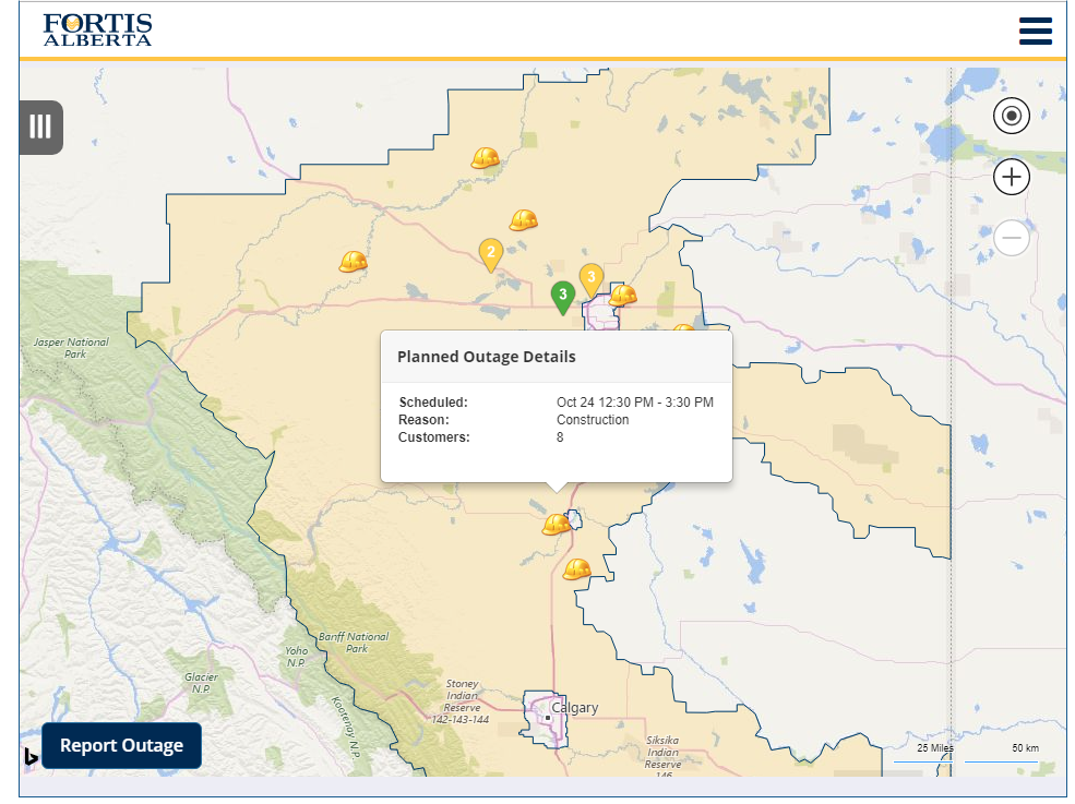
Alberta. Fortis Alberta. The FortisAlberta Outage Map shows both scheduled and unscheduled outages. Twitter: @FortisAlberta. Updated August 1, 2014. Thanks to Bil Simser.
British Columbia: BC Hydro Power Outages Map. Call 1-888 POWERON (1 888 769-3766) to report an outage. RSS outages feeds show outage details broken down by municipality and region, available in standard RSS formats for automated use updated each 15 minutes.
New Brunswick: NB Power Current Power Outages. (no map) (updated 11/2/2014)
Newfoundland: Newfoundland Power Outages Map.
Nova Scotia: NS Power Outages is an independent outage tracking log, based on data and reports from the Nova Scotia Power Live Outage and Restoration Map.
Ontario: Hydro One Storm Centre. Call 1-800-434-1235 to Report a Power Problem.
Ontario (Guelph) Guelph Hydro Power Outage Map. Map overlay shows both power outages and recent lightning strikes. Powered by Arcgis. Twitter: @GuelphHydro.
Ontario (Missisauga) Enersource Power Outage Map. To Report Outages please call 905-273-9050.
Ontario (Ottawa): Hydro Ottawa Power Outage Map.
Ontario (Toronto): Toronto Hydro Power Outage Map. To report a power outage, please call 416-542-8000. Twitter: @TorontoHydro. Facebook: TorontoHydro.
Prince Edward Island. Maritime Electric, a Fortis Company. No maps. Call 1-800-670-1012.
Quebec. Hydro Quebec Power Outage Information (no maps). A table of Hydro Quebec power outages is provided (in French only) with detail to service interruption locations.
Saskatchewan. SaskPower Outages (no maps).
Australia (SE Queensland). Energex. Energex Current Interruptions (no maps).
Bangladesh. Power Grid Company of Bangladesh, Ltd (no maps). Hourly generation and load shedding table shows unmet demand. (Updated 11/2/2014).
Kenya. Kenya Power. Facebook: @KenyaPowerLtd. Twitter: @KenyaPower.
Mexico. CFE (Comisión Federal de Electricidad) (no maps). Twitter: @CFEmx
New Zealand: Orion New Zealand Outages. Twitter: @OrionNZ
South Africa: Eskom (no maps). When demand exceeds supply, Eskom does load shedding. Twitter: @Eskom_SA ; Twitter hashtag #eskom . [Updated 11/2/14]
Venezuela: Crisis Eléctrica Venezolana is a weblog by Jose Aller in Venezuela who is tracking the widespread power outages in that country in 2011. Map is based on tweets with the tag #sinluz.
Credits
Original content by Edward Vielmetti.